12.9.24 – SIW – Zach Jones

In discussing the district-wide layer of security, the PASS School Safety & Security Guidelines address the importance of facility and vicinity mapping, and marking entrances with a first responder numbering system
We know that schools pose distinct challenges for emergency responders due to their size, complexity, and diverse range of occupants. Respondents need comprehensive yet easily digestible information in an attack or other emergencies. It is essential for districts to ensure that each facility can supply critical details, including an overall floor plan, roof plan, fire safety measures, HVAC systems, security protocols, and other emergency information that would benefit police, fire departments, and other emergency partners.
As per the guidelines, this information should include:
- The location of the rapid access security vault (RASV), a secure storage device where access credentials (keys and cards) are kept for emergency access.
- Printed or electronic copy of “As-Built/Record Drawing” of the facility. Plans should include all room names and associated numbers.
- Printed or electronic copy of an aerial view of the subject facility. This should include a minimum five-block radius outside the school property perimeter.
Many look to a dependable interactive mapping solution to amass this data to provide real-time, detailed, and accessible school campus maps. These maps enhance school safety while streamlining operations and even reducing costs. But what exactly is interactive mapping and how does it benefit schools?
Understanding Interactive Mapping in Schools
Interactive mapping is a digital solution that’s a lot of what it sounds like — an interactive map.
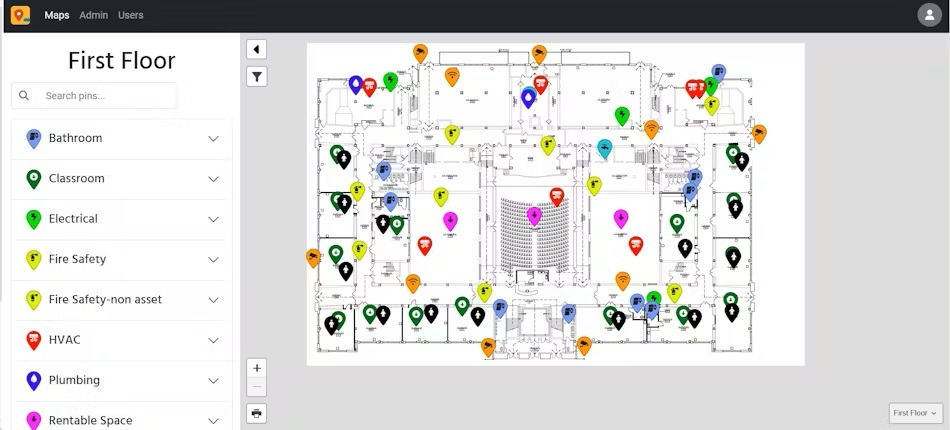
Users leverage it to visualize detailed school layouts. These maps physically document classrooms, exits, hallways, security cameras, fire extinguishers, and emergency supplies.
Unlike traditional static blueprints, interactive maps are dynamic. That means they reflect real-time updates to campus infrastructure or safety protocols.
Interactive maps allow users to pin critical areas like exit doors, gathering places, or evacuation routes. These pins offer a clear visual guide to ensure everyone safely exits the building during an emergency.
This capability also helps districts in non-emergency situations. Users can monitor hazard areas and mark places that need remediation, like asbestos locations. Leaders can then track these safety hazards until workers resolve the issue.
Interactive Mapping for K-12 Safety
Industry professionals and parents alike know what’s at stake in schools. Safety dominates much of the spotlight placed on today’s education system. As a result, leading districts leveraging interactive mapping can expect:
Improved Emergency Response Time
In an emergency, every second counts. Interactive maps provide crucial details about school layouts for those on the scene.
Users can identify exact issue locations and surrounding areas. Personnel can easily identify key access points, locked doors, and evacuation zones. This information helps school officials perform emergency shutoffs or locate critical equipment during a crisis.
Real-Time Map Updates
School campuses constantly evolve. New renovations, expansions, and safety upgrades occur regularly.
Interactive mapping lets schools update their maps in real-time, ensuring users have the latest information. These updates are critical for preparation, such as safety inspections or fire equipment maintenance. Users can utilize the latest updates to locate and inspect emergency equipment to ensure it’s in working order.
Increased Collaboration with First Responders
Interactive mapping fosters better communication between school officials and local emergency teams. Staff leverages the latest information to brief law enforcement or medical teams during emergencies or routine drills.
The visualizations ensure that everyone is on the same page. They can even help first responders familiarize themselves with school layouts and security measures before a crisis occurs.
Detailed Evacuation Planning and Drills
Interactive maps also help districts plan and conduct school evacuation drills. Administrators can use the maps to design and implement precise evacuation routes tailored to emergencies like fires, tornados, or intruders.
By pinning important areas such as exit doors or assembly points, districts can better prepare for evacuations and ensure that drills are as effective as possible.
Centralized Safety Data Hub
Interactive mapping also centralizes safety data. Beyond displaying building layouts, it consolidates information into one location, streamlining stakeholder collaboration and communication.
Event Safety Enhancements
Schools can also view upcoming events and work orders on the maps, allowing them to monitor event locations during emergencies and resolve issues faster. Knowing the area layout increases efficiency, whether it’s a planned school assembly or a last-minute work order.
Why interactive mapping?
With all that’s at stake in schools today, it’s critical that districts leverage the most advanced technological solutions available. Interactive mapping gives employees, district officials, and first responders a more effective method for enhancing school safety.
Interactive mapping is a powerful tool for enhancing school safety. It provides real-time, detailed building visualizations and displays locations of emergency equipment and potential hazards. By integrating it into their safety plans, districts can ensure a safer environment for students, staff, and visitors.
The Partner Alliance for Safer Schools (PASS) is a nonprofit 501(c)(3) bringing together expertise from the education, public safety, and industry communities to develop and support a coordinated approach to making effective and appropriate decisions concerning safety and security investments. You can download the complete PASS Guidelines here, or check out our PASS Safety and Security Checklist for quick tips on how to get started. These resources—as well as white papers on various topics including barricade devices, lockdown drills, and more—are free.

About the Author
Zach Jones | Content Manager at FMX
Zach Jones graduated from Ohio University, where he studied journalism before getting his MBA from Ohio State. When Zach isn’t working, he enjoys hiking, cycling, traveling, and spending time with his family. He is a big Cleveland sports fan and spends too much time golfing and playing slow-pitch softball.
